


How did a development with major detrimental effects on the Quaggy get approved?
There is no doubt we live in more enlightened times than 1989, when the National Rivers Authority threatened the Quaggy with virtual extinction through canalisation. Although flawed in some respects, the recently completed Flood Alleviation Scheme has transformed Sutcliffe Park and protected its future, as well as that of the other green spaces used for flood storage. It’s a textbook example of what can be achieved when agencies and authorities work together with the local community.
But are government agencies and local authorities really paying any more heed to local communities affected by unwelcome schemes than the NRA did almost twenty years ago? They will assure you they are. We invite you to make your own mind up.
The location of the site
The site, consisting numbers 36–56 Lee High Road, is less than 250 metres from Lewisham clock tower. Numbers 36–54 form a terrace of single storey shops, while number 56 is a three storey building with a two storey extension behind. The first picture shows the current frontage of the site looking westwards from number 56 (Handicars).

Lee High Road, looking westwards
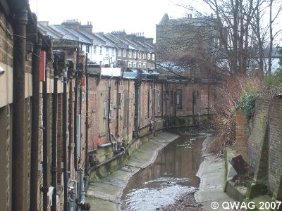
The site is squeezed between Lee High Road to the north and the Quaggy to the south. For almost half its length the site is no more than 15 metres wide. The second picture – a side view of number 18 Lee High Road taken from Clarendon Rise bridge, a short distance downstream – clearly shows how narrow the site is in this vicinity.

Side view of number 18 Lee High Road taken from Clarendon Rise bridge
An earlier planning application sought to erect a part five, part six storey apartment building, including shop units on the ground floor. This was deemed unacceptable and the revised application, lodged in June 2006, has one storey less. The current frontage of the site looking westwards from number 56 (Handicars) A side view of number 18 Lee High Road clearly shows how narrow the site is in this location
Why QWAG objected
QWAG objected to this development for five reasons.
1. Shading of the river corridor. The application incorrectly stated there will be no effect on the solar shading of the river. In fact a part of the development is to the east of the river and here the developer is proposing five storeys. No daylight and sunlight survey, that would have proved our assertion, was carried out for the river corridor.
2. Creating an inappropriate landscape for the river. The proposed development will ‘canyon’ the Quaggy. It is now generally acknowledged that a vertical wall of building, continuing straight up from a riverbank, is an inappropriate landscape setting for a river in an urban environment.
3. Wind funnelling and microclimate changes. The proposed development will change the current one storey river wall to one of five storeys. This will affect the microclimate of the river corridor here and will cause significant changes to the air movements over this section of river.
4. Artificial lighting. The huge increase in the number of residential windows directly overlooking the Quaggy will increase the artificial light levels in the evening and at night. The light pollution will significantly adversely affect much of the wildlife on this refuge section of the river.
5. ARUP’s Ecological Impact Assessment. Although the report talks of ecological improvements, as far as we can see, all the described improvements to the river are ones that are being carried out by the Environment Agency as part of the current Flood Alleviation Scheme, and thus do not represent opportunities from the proposed development.

Quaggy flowing along the back of the site. The building is planned to rise five storeys directly from the riverbank, ‘canyoning’ the river. The Quaggy flowing along the back of the site
A shock from the Environment Agency
In November, QWAG’s objections were undermined by the shock announcement from the Environment Agency that it had “no objection in principle” to the development. Yet, in the very same letter it expressed “serious concerns that the buildings will act as a precedent in terms of height, massing and proximity to the River Quaggy. This will in effect ‘canyon’ the river against tall buildings, which will detrimentally impact on the river corridor and its associated wildlife and landscape character. Exactly what QWAG were saying!
The letter also pointed out that “Such developments would also preclude the opportunity for river restoration of the River Quaggy to take place due to the close proximity to the river.”
QWAG immediately lodged an amended objection, pointing out that the comments made by the Agency strongly supported our position. In fact, some of them were so critical of the impact of the proposed development on the immediate environment, QWAG was astonished that the Agency had stated it had “no objection in principle.”
At the planning meeting
Another shock awaited QWAG at the planning committee meeting on the 18th January 2007. Our letter of objection was summarised, but not fully reproduced, in the brief presented to the committee. The brief referred to the London Plan, drawing attention to policies that supported the development. Yet it omitted QWAG’s references to relevant policies in the same document that seek to protect rivers and river corridors.
Again, Lewisham’s Unitary Development Plan was referred to, but the policies that directly seek to protect the river and its environment were omitted for reasons that are unclear.
There was a further serious omission. As we had pointed out, a part of the development is to the east of the river and will cause solar shading of the river corridor. No daylight and sunlight survey was carried out for the river corridor. We regard the failure to include this part of our objection in the brief as a serious oversight.
The developer’s representative gave a presentation lasting over 10 minutes. Despite this being a major development only one objector was allowed to respond, and he was limited to a mere five minutes. Then the principal planning officer summarised the deficient brief, drawing attention to the reasons why the application should be approved. After asking a few perfunctory questions the committee voted in favour of the development by three votes to two.
Lessons for the future
The lessons for future objections are clear. If the Environment Agency cannot be persuaded to object to similarly detrimental developments, and the planning department is allowed to continue briefing planning committees selectively and partially, the prospects for Lewisham’s rivers are bleak.

The next target: Numbers 18–34 Lee High Road
The Agency’s “serious concerns that the buildings will act as a precedent in terms of height, massing and proximity to the River Quaggy” have already come to pass. The developers of 36–56 Lee High Road have plans to extend their apartment building at the same height as far as Clarendon Rise, replacing numbers 18–34, pictured here. They are buoyed no doubt by an indication given by the principal planning officer that such a move would likely gain approval.
QWAG have asked the Environment Agency to clarify why it had “no objection in principle” to this development. We have also instigated an official complaint with Lewisham Council over the selective contents of the planning brief and the partial way it was presented. We await the replies with interest.
How bitterly ironic it would be if the river that was saved from extinction through canalisation now begins to suffer from creeping ‘canyonisation’ instead.